Virtually all BTO surveys now rely heavily on the use of Ordnance Survey grid references, yet to the uninitiated they can be confusing. Here Simon Gillings explains what grid references are and how to give complete grid references for bird surveys.
Two centuries of development
In 1791 the Ordnance Survey was founded as Britain's national mapping organisation, mostly to produce maps for military purposes. In 1799 Ordnance Survey rose to the challenge of invasion from France and the entire OS staff was sent to the English south coast to survey the counties thought at most risk. This led to the production of the first Ordnance Survey map in 1801 of Kent.
So it was that the Ordnance Survey began, though we would not recognise it until following the Second World War when the recommendations of the Davidson Committee brought about the metric National Grid. Prior to the National Grid, many counties had different projections and matching maps at county boundaries was notoriously difficult. In 1947 the first map was published bearing the National Grid on its cover. This grid provided the first truly national map referencing system by which any place in the country could be given a unique reference.
Grid references

A complete grid reference consists of three parts - an alphabetic prefix, followed by numeric eastings and then numeric northings.
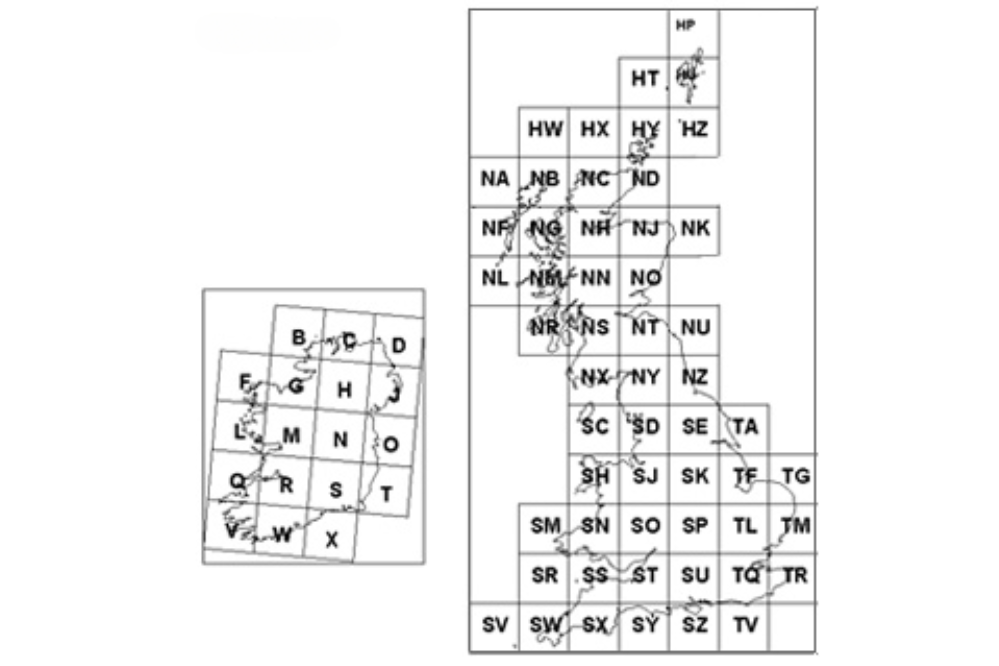
Britain and Ireland are split into 100km by 100km squares (termed 100-km squares). In Britain, these are given a two-letter alphabetic reference whereas in Ireland they are given a single-letter reference (rarely given as IB, IC etc).
This map shows the National grid with 100-km squares labelled with the alphabetic prefix. Note that, because the grid is square and is imposed on our round earth, the grid is not necessarily parallel to lines of latitude or longitude.
Which 100-km square?
By referring to the map's key you can find a diagram showing which 100-kms are shown where on the map sheet - on some maps the alphabetic prefix is also printed in the corners of the map and wherever the 100-km changes (e.g. the pink 1:50,000 OS Landranger Series).
Whenever you give a grid reference you should always include this prefix - sending in a sighting of a flock of Tree Sparrows at '7233' means we cannot determine whether they were in Norfolk, on the Isle of Mull or on Snowdonia.
The numbers
A grid reference always refers to the south-west or bottom left-hand corner of a square but many people get confused by which numbers to give first - do you use the ones along the bottom of the map or those up the side first?
- The answer is the eastings come first - those are the numbers running along the bottom of the map and determining how far east you are.
- Next come the northings, the numbers up the side of the map.
You can come up with your own way of remembering them. I think of them as Across first and Up second because A is before U in the alphabet.
What scale?
The number of figures in the grid reference determines how accurately you define a point:
- a 2 figure grid reference, e.g. TF73, identifies a single 10-km square;
- a 4 figure grid reference, e.g. TF7233, identifies a single 1-km square;
- a 6 figure grid reference, e.g. TF722336, identifies a point to the nearest 100m.
Reading the grid reference
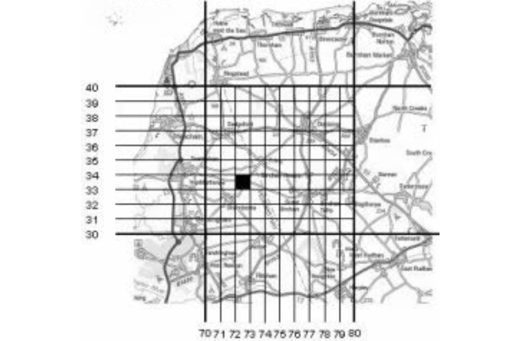
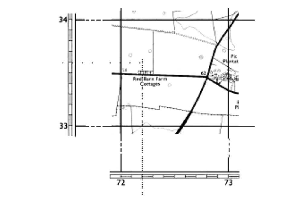
These figures show extracts from a road atlas and Ordnance Survey Pathfinder sheet 839 covering an area where I saw a flock of Tree Sparrows (shaded square). The 10-km square is shown in bold with its constituent 100 1-km squares.

2- and 4-figure grid references
To give the grid reference, start with the alphabetic prefix. I know I was in north-west Norfolk so from Figure 1 the 100-km square must be 'TF' (also printed on the cover of the Pathfinder map).
The eastings, the numbers running across the bottom, read '72' for the bottom left-hand corner of the square the birds were in. The northings, the numbers up the side, read '33' for the bottom left-hand corner.
- To give a 2-figure grid reference give the first digit from each - so the 10-km square is TF73.
- The 4-figure grid reference giving the 1-km square is TF7233.

6-figure grid references
To be more precise, give a 6-figure grid reference indicating where, to within 100 m, the birds were within the 1-km square.
The dotted lines overlaid on the right-hand map show where the flock was - it was 2 tenths east of the grid line and 6 tenths north of the grid line.
- The 6-figure reference is TF722336.
Tetrad references

Some surveys use tetrads rather than 1-km squares. A tetrad, after the Greek tetrads meaning four, is a group of four 1-km squares arranged into a 2km by 2km square.
There are 25 tetrads within each 10-km square and they are identified by an alphabetic suffix after the 10-km square's reference. The 25 tetrads in any 10-km square are labelled from A to Z (excluding O to prevent confusion) as shown in this figure.
The Tree Sparrow flock I saw in Norfolk was in the 10-km square TF73. By overlaying the tetrad grid onto the 10-km square in Ordnance Survey Pathfinder map, the tetrad letter must have been G.
- The full tetrad code was TF73G.
For more information
- Visit the Ordnance Survey website, or in Ireland visit osi.maps.arcgis.com.
- See the Ramblers guide to navigating